Logo

Login/Register

STAY IN THE LOOP

Sign up for our newsletter

  • Home
  • About
  • Urban Nature Program
  • City Dashboard
  • Knowledge Resources
  • Events
  • News & Blogs
  • Partnerships

City Dashboard

The GPSC Urban Dashboard was developed to spatially locate the platform’s cities and knowledge partners together with case studies and other data relevant for its work. To use the dashboard, either click on icons or jurisdictions on the map, or select options from the dropdown menu at left. Information regarding the platform’s approximately 30 cities can be found in the dashboard along with links to available knowledge resources on GPSC’s website.
 
A selection of layers can also be viewed over the map, for instance showing the global biodiversity hotspots which are important for GPSC’s work supporting urban biodiversity.

City Dashboard

Legend

  • GPSC Cities
  • GPSC Knowledge Partners
  • Case Studies

Disclaimer

This map was produced by the Map Design Unit of The World Bank. The boundaries, colors, denominations and any other information shown on this map do not imply, on the part of The World Bank Group, any judgment on the legal status of any territory, or any endorsement or acceptance of such boundaries.

Source:

GEF Protected Areas : United Nations Environment Programme-World Conservation Monitoring Centre. 2019. User Manual for the World Database on Protected Areas and world database on other effective area-based conservation measures: 1.6. UNEP-WCMC: Cambridge, UK. Copyright 2019 United Nations Environment Programme. http://wcmc.io/WDPA_Manual,https://www.protectedplanet.net/en/thematic-areas/wdpa?tab=WDPA

Tiger Conservation Landscapes : Tiger Conservation Landscapes by Global Forest Watch (GFW) CC BY 4.0

Biodiversity Hotspots : Biodiversity hotspots by Global Forest Watch (GFW) CC BY-SA 4.0

Roads : Center for International Earth Science Information Network - CIESIN - Columbia University, and Information Technology Outreach Services - ITOS - University of Georgia. 2013. Global Roads Open Access Data Set, Version 1 (gROADSv1). Palisades, NY: NASA Socioeconomic Data and Applications Center (SEDAC). https://doi.org/10.7927/H4VD6WCT

Railways : Made with Natural Earth https://www.naturalearthdata.com/downloads/10m-cultural-vectors/

City Dashboard

City Benchmarking

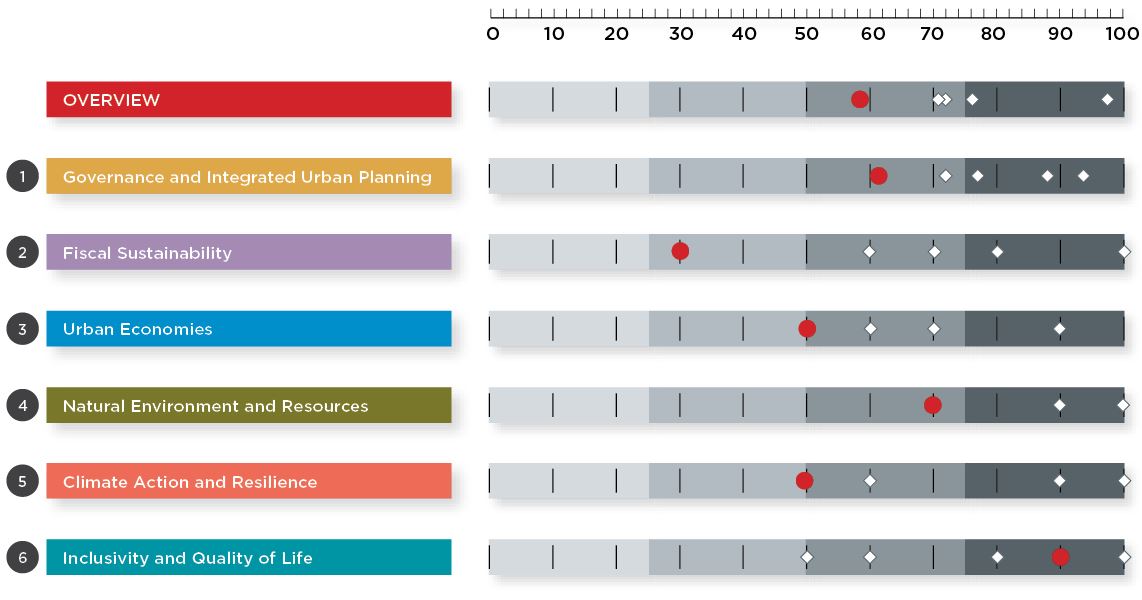
Assessing the sustainability of cities through their planning, building, and management actions can provide insights of how to approach their common or individual challenges and opportunities. Through GPSC’s work a range of cities have been benchmarked and the findings will gradually be made available on the City Dashboard. Also, the featured layers below show a pool of urban indicators provided by diferent organizations. 

Featured Layers

World Population Density by Lumino City

Street-Network Sprawl by Sprawl Map

Forest Greenhouse Gas Emissions by Global Forest Watch

Global Human Settlement Layer by the European Commission

Urban Biodiversity Hotspots by Global Forest Watch


Gpsc Washington, DC Headquarters
E-mail: gpsc@worldbankgroup.org

©2021 GPSC. All Rights Reserved

  • Legal
Navigation
  • Home
  • About
  • Urban Nature Program
  • City Dashboard
  • Knowledge Resources
  • Events
  • News & Blogs
  • Partnerships
STAY IN THE LOOP

Sign up for our newsletter